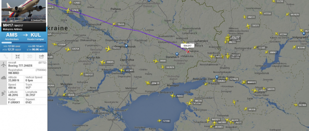
Flight MH17 never deviated from flightplan route nor did it take other route than previous days

Some blogsites and many Tweets want to believe you flight MH17 took at diferrent route on July 17 than on other days in July. People want to believe you that Ukraine Air Traffic Control sent the aircraft deliberately over a war zone.
This is not true. The flight took the same route as many days before. It made a small deviation to the north because of weather on request by the crew.
Russian media show maps which shows previous routes which are not correct.
Lets prove this.
Flightradar24 is a very reliable way to track aircraft. Most civil aircraft have a transponder which transmits the aircraft height, speed, altitude, registration and flightnumber on a radio frequency. Using very simple equipment that data can be received by anyone interested. Many people worldwide have such equipment and voluntarilty feed Flightradar24 with data.
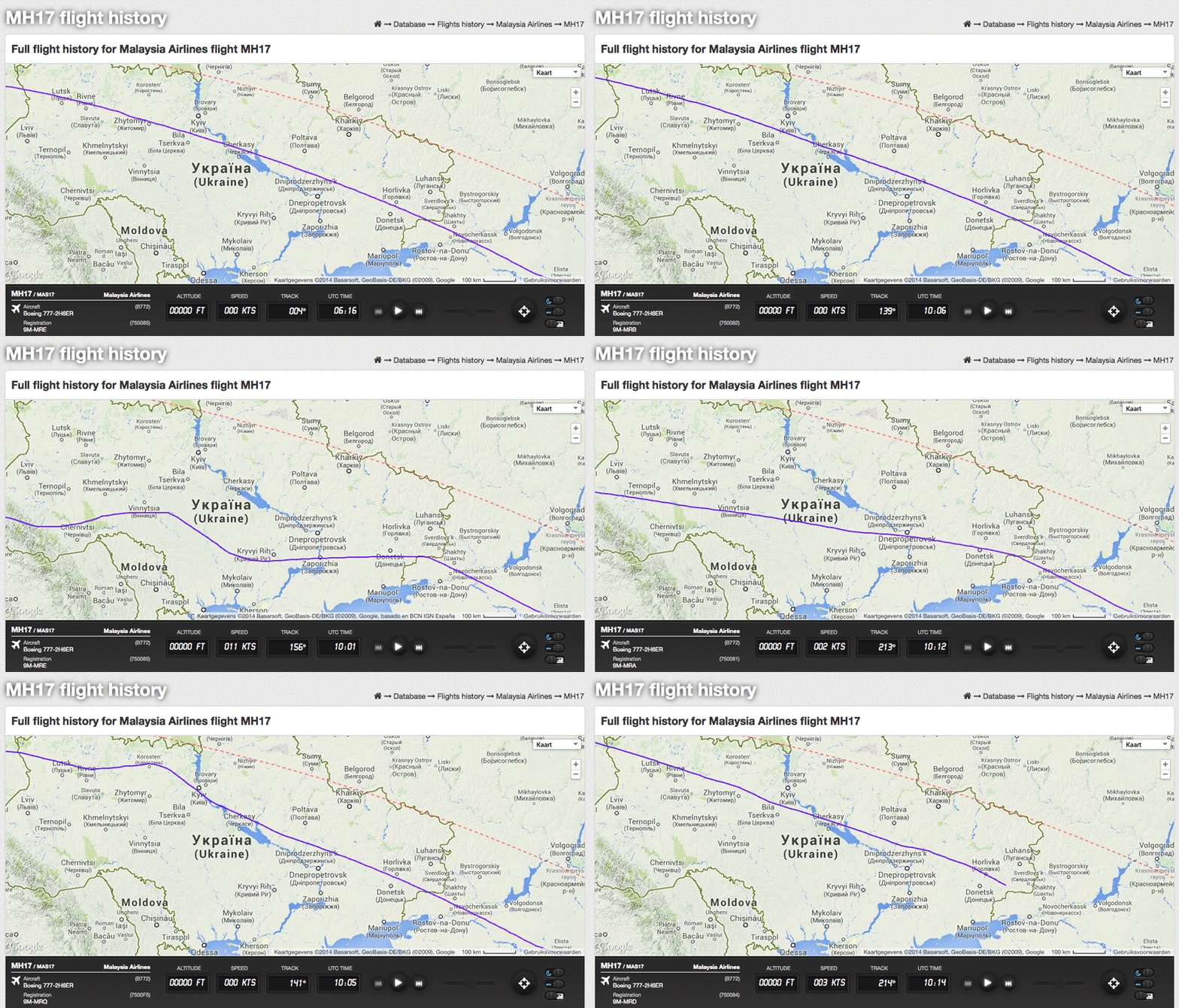
Below are three screendumps I made of MH17 flights. The flights were made at July 15, July 16 and July 17. It is easy to see the flights path are almost identical.
The next image shows an image of the flightpath suggested by Russia Today. Russia Today is a President Putin controlled tv station. Russia Today quotes Flightaware as its source. Notice that the flightpath of MH17 shown on Flightaware is a following a perfect route around the globe after entering Ukraine airspace. Notice as well the track changes from green to white. White indicates Flightaware did not receive a transponder signal from the plane. The reason for this is that Flightaware does not have a feed, unlike Flightradar 24, in Ukraine Coverage of Flightaware feeds is made clear here.
All flight paths of MH17 in the last 2 months or so can be viewed a Flightradar24. Click on the small plane icon at the end of the line.
All flights of MH17 at July 15,16 and 17 entered Ukraine airspace around Lublin in Poland.
They all flew slightly north of Donetsk.
They all flew above separatists controlled area on July 15,16 and 17
The red dotted line shown in all images below show the shortest possible route between Amsterdam and Kuala Lumpur.
The image below shows the flightpath of MH17 as flown in July 15!
Many other airlines were using the same route. For example Singapore Airlines on the Lodon Heathrow to Singapore route. See the image below for showing the route flown on July 16. Same route as Malaysian Airlines.
The image below shows the flightpath of MH17 as flown on July 16. See the registration of the aircraft in the left bottom corner: 9M-MRA
The aircraft flew slightly north of Donetsk.
A user on website metabunk.com made an animation of the MH17 flights operated between July 8-July 17. See it here.

Now lets look at the flight path of MH17 the next day, July 17. As shown on Flightradar 24 here.
The flightpath looks almost similar to the two days before. There is a small deviation to the north which started just north of Dnepropetrovsk. On July 15 and July 16 the flight overflew the separatists area as well.

Now lets look how the same flight is covered by Flightaware.
The picture below shows coverage of Flightaware. Clearly seen no coverage in Ukraine or further East.

This is the Flightaware track of July 16.
It is clearly visible the track color changes when the aircraft crossed the Polish-Ukraine border.

Now lets have a look how the Russian media and Russian state presents the routes.
In this article on Russia Today it states :
As you can easily conclude yourself using flightradar, the above is simply not true. Yes, MH17 of July 17 flew right over warn-torn Donetsk Region. But flights on July 15 and 16 as well!
The image below is used in the same article. The red line shows the flightpath according Russia Today. The aircraft was overflying the Crimea. Now scroll back in this article to the flightpath of July 15 as shown by Flightradar! Big difference.
In reality MH17 flights of July 15,16 and 17 flew almost the same route.

Now lets look what the Russia State presented during a press conference. See the slides here.
This image presented by Russian State shows a dramatic change of course of MH17 just above the city of Donetsk. This change is not shown in the Flightradar track.
I added the right arrow into the picture to indicate the flightpath of MH17 as presented by Russian State. The red line clearly makes a turn towards to northeast, then goes back southeast.
So it is up to you to judge who is right!


I wont spend any time trying to find out who you are, or what your agenda is. Enough to say that I already trust enough in my knowledge of the US State dept, and the methods they will use to propagate disinformation. I have no trust in anything the Yanks say about this. The Russian intel dump was good enough – the yanks had military exercise and a specialist satellite over the area … where is their ELINT data from these two sources. They lied so much over the last twenty years, and this will be no different. MH17 was taken down by air-to-air weapons…. end of story. Whoever you are, your attempt to spike the intel on this is failing. Go back under the rock.
Clearly this web site is not run by “US State dept”.
Please note that there exist other people outside Russia borders beside “Yanks”.
Just in case someone still think: “MH17 was taken down by air-to-air weapons”
Note these:
1) primary radar does not show any f.jet in range/position to do the damage we see on MH17: https://whathappenedtoflightmh17.com/russian-radar-does-not-show-any-ukraine-fighter-aircraft/
2) damage match only with BUK missile launched from ahead of MH17 flight path (from rebel held area): https://www.onderzoeksraad.nl/en/onderzoek/2049/investigation-crash-mh17-17-july-2014
You are wrong – where were another Ukraine aircraft around mh17 (but mh17 was shut down by buk system):
1. Civil Russian radars show another aircraft above 5000 after mh17 shut down and it fly around (read your link).
2. Damage like mh17 you can see on SU-25 crash on July 16. Official Ukraine version: it was shut down by Russian Mig-29 air-to-air missile:
http://lostarmour.info/media/images/id8327-19.jpg
http://lostarmour.info/aviation/item.php?id=8327
Learn basics of radar and stop spreading lies.
https://whathappenedtoflightmh17.com/russian-radar-does-not-show-any-ukraine-fighter-aircraft/
The spot RU MOD show is clearly forward fuselage debris.
international aviation agrees.
“2.” Is very naive and childish.
Proven not to be by MIG29.
Damage different and minor vs MH17.
There’s more to be said about the flight plan deviation claims.
The RT article stated: “According to data at flightaware.com”. Now it was not a good source of information as was shown by many later but that doesn’t make that statement itself incorrect. The confusion arose when the Flightaware database started to contain the augmented information for July 17 but not (yet) for the days before the 17th until nearly one week later. This major discrepancy made, for a few days at least, people cry foul all over the web.
It’s hard to find a reliable source for the above but at least some possible screenshots are here: http://21stcenturywire.com/2015/07/17/mh17-one-year-on-what-really-happened-and-why/
As for the Russian MoD presentation on Monday July 21st, they’re indeed not using the right flightpath as was released later on but they went for the slightly southern W633/L69 route instead of L980 using possibly the known exchange at 13.00 hrs for a request and permissions for a diversion of the track “20 NM to the left, due to weather”. Although DSB stated *months* later only 3.6 NM north was done, the Russians note here a max of 7.5 NM from left border of “their” selected corridor. The normal corridor is 10 NM wide, meaning 12.5 NM instead of 3.6 NM north of center (L980) as established by DSB.
[note: for a sample of all the airways crammed in that space see eg NOTAM pdf of BSD https://www.rijksoverheid.nl/binaries/rijksoverheid/documenten/rapporten/2014/11/13/bijlage-1-notam-mh17/lp-v-j-0000006835.pdf ]
Now why the W633/L69 route instead of L980? The Ukrainian radar screen displayed on the “sample image” in the DSB report indeed W633 (brown line, page 39) and no other, as to indicate how much they seemed to have converged. This all means that the *actual* position of MH-17 at the time in combination with the northern diversion (22NM requested) might have lead the assumption that W633/L69 must have been the original route?
As long as it’s not clear why exactly Russia went for W633/L69 instead of L980 (as we know now), the question of motive will remain murky. However it explains perfectly and consistently that strange “northern” turn discussed in the press release since it was relative to a wrongly assumed airway. But positional it was still correct and there was indeed deviation but not going outside the intended busy L980 corridor.
What I mean with this all is that mistakes have been made by newspapers and officials on all sides, all the time. Bias, selective sources and jumping to conclusions based on some visual. It’s only easier to see it being done by the “other” but very hard to admit it to ones own false conclusions. As we’re all starting to find out slowly I think unless someone is starting up again the fog of a war to prevent exactly that.
(Disclaimer: as not to look all too pro-Russian, I currently still find it most likely that Russians operating a BUK downed MH17 (in the Georgian war they downed a few of their own, so they’re not that sophisticated) but that Ukraine might bear a lot more of the responsibility than currently admitted).