How likely is a blue sky in Torez at July 17 around 12:30?
One of the photos of the BUK enroute to its supposed launch location was made by an anonymous photographer in Torez. The exact location is near a petrol station at 48.023969, 38.614448. On Google Maps the location is .
The weather looks very nice. All blue skies. As the weather in the area became cloudy in the afternoon, could this photo be made around 12:30 in Torez at July 17?
Let us try to find out.
The view of the photo is roughly towards the northeast. We see an almost blue sky with lots of sunlight seeing the clear difference between shadow and non-shadow. This means likely there were no clouds in the path from the location of the sun towards earth.
Sun was almost exactly from the South at 12:30.
According Bellingcat the photo was made around 12:30. The time was estimated by using suncalc. Michael Kobs calculated the photo was made around 12:07 local time. Ukraineatwar estimates a time around 12:27
Previously the BUK was seen in Zuhres. The distance between two locations is about 24 km. The truck with BUK on a lowloader would require about 40-45 minutes to reach Torez from Zuhres at about 30 km/h.
The weather at Zuhres aroud 11:40 was sunny but there are no 100% blue skies. Clouds can be seen. I guess it is about 80% overcast.
To verify the weather conditions in Torez at around 12:30 we need more photos.
At 17 July around a convoy of tanks passed Torez from Donetsk. Two videos are published on Internet. These are made from the same location.
First this video. It clearly shows the sky was not completely blue over Torez.
Ukraineatwar calculated that this convoy was filmed between 12:30 and 13:30 local time. That is about the same time the BUK was photographed from the petrol station and next to Furshet market in Torez.
Ukraineatwar geolocated the location where these two videos were made. Here is the Google Maps .
The view of the video is pictured in the image below. It is roughly west to northwest.The position of the cars from which the videos were made is 48.019560, 38.650751
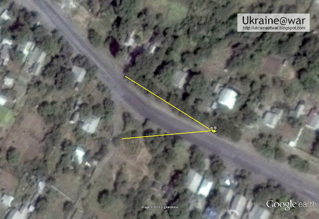
The image below shows the line of sight of both photos.
The red lines show the line of sight of the BUK photo made around 12:3o at the petrol station in Torez.
The green lines shows the line of sight for the videos made of the Vostok convoy between 12:30 and 13:30.
There is a Russia Today/Ruptly It does show that there are no blue skies anymore.
Let us have a look at the photos a NASA satellite made. NASA publishes photos of two satellites caled Terra and Aqua.
The photos of Terra are made a few hours earlier than photos of Aqua. Aqua made a photo of the area at around 09:55 UTC (or 12:55 local time). This image shows the trajectory of the aqua satellite on July 17, 2014.
/GLOBAL2014_07_17_198_aqua.gif)
NASA Worldview shows two photos taken at July 17 of the area. Lets select the Aqua photo .
Worldview allows to exactly pinpoint locations by looking at the latitude longitude locations in the rightlower corner of the window. I made a screenshot of the Aqua photo which was made at around 09:55 UTC \ 12:55 local time.
The green lines show the line of sight of the video made of the Vostok convoy aroud .
The red lines show the line of sight of the BUK photo made from the petrol station in Torez at aroud 12:30
The area in the red lines show not show a heavy overcast sky. However there is a thin layer of clouds visible. The BUK photo however shows a clear sky.
On July 16 the weather in the area was very nice. No clouds to be seen as this photo shows.
There is another video showing the weather conditions in the morning of July 17. It shows the Vostok convoy on its way to Torez. The video at the end is made at a location 48.032127° 38.542169°. It is close to a small village called Hirne and about 2 km west of Torez.
The end of the video the camera moves toward facing the East. (direction Torez). It is clear there are already some high thin layer of clouds visible.
Michael Kobs estimated using shadows and sunclac tool that the convoy passed at aroud 12:45 local time. The Vostok convoy is about 40 minutes to a hour behind the BUK convoy. This is confirmed by various tweets which report a convoy of three tanks between Shahtersk and Torez around 12:45. At 13:15 local time time Vostok convoy is seen in Torez according t
So the screenshot below shows the weather situation around 12:30-12:45. The line of sight is facing towards the north- north-east.
Again there are some blue patches but here as well some high clouds are visible.
SAT24.com has several photos showing the weather above Europe. The photo does not show Eastern Ukraine in detail but the development of clouds at the end of the morning is clearly visible.
The four arrows in the left upper Google earth image are pointing to (from left to right) Donetsk airport, Grabovo, Torez, Saur Mogila.
The photo bottom left is made by teh Nasa Terra satellite. It shows the same situation as the photo taken at 8 UTC.
This is an image taken by the NOAA19 satellite at July 17 11:00 UTC. The arrow points to Torez.There is an area with fewer clouds visible.
This website has many satellite photos. This thread also has many photos.
Zoomed in on Torez the image looks like this
The preliminary report of DSB showed a satellite photo of the area. The photo was taken at 12:00 UTC . So we are looking at the situation at 15:00 local Donetsk time.
The original image has been adjusted by adding Torez and the map below.
Conclusion
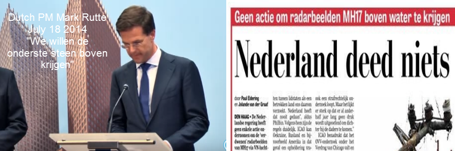
Novaya Gazeta reports that the BUK was delivered to an area near Torez-Snizhne in the night of 15-16 July.
While it cannot be excluded it seems unlikely the photo of the BUK was made at July 17. Satellite photos and videos all show a partly clouded sky. For 100% proof more photos from Torez facing towards Northeast are needed.
It is not unlikely the photo in Torez was made at July 16 as the weather had all blue skies at matches the Novaya Gazeta story.
Admin:
Can you also publish the images of clouds over east Ukraine available on sat24.com from 10 am, 11am, 12 noon, and 1 pm?
The ones between 10 am and 11 am establish that there were relatively clear skies over Zhures, Shakhtersk, Torez, so that a Russian satellite could take a picture of Ukrainian BUK’s at Zaroshchenske at 10:30 am (11:30 am Moscow time). Between 11 am and 12 noon clouds start coming in, but I think they show the sky should have been clearer in the view southeast from Zhures than is shown in the pictures/video.
Admin:
The NG article and several other articles suggest this picture:
1) Ukraine left behind 10 BUK’s when they withdrew assets from Donbass bases in March.
2) Ukraine failed to take all of its missiles from the Donbass bases and some of these were captured by the rebels – likely the Lugansk base.
3) Ukraine deployed BUK’s into the ATO zone and documented it with ground images.
4) Russia has provided uncontroverted space imagery of Zaroshchenske showing Ukrainian BUK’s in the kill zone. America seems very uninterested in releasing an image of this area from July 17 showing no BUK’s present which would end the speculation. Its hard to believe a single American satellite did not fly over and photograph the region Amvrosievka-Shakhtersk between 9 am and 2 pm. If Digital Globe’s satellite could take a picture at a 45 degree angle from the south of the region Donetsk-Khartszyk and another of Lugansk-Lutgino at 11:08 am Kiev time, obviously the same satellite took pictures of the region Zhures-Snizhne-Amvrosievka at the same time and the same day, but these are not approved for release to the public.
Conclusions:
1) If and when BUK parts are found in the MH17 site they will be Ukrainian origin.
2) Ukraine cannot provide an accounting of its missiles without admitting some were lost or used.
3) Ukraine cannot provide an accounting of its BUK launchers without admitting many were left behind in grasp of the rebels.
4) Ukraine cannot provide deployment information of its BUK’s on July 17 without admitting some were placed inside the kill zone.
5) Russia can open its missile inventory for inspection and show none are missing.
No matter what Ukraine does with its information, she will look guilty, even if innocent. This is the only reasonable explanation of why Ukraine releases no information at all that would clear itself and why America will not release any space imagery.
Point 4 above.
I look on Google Earth and I see images from both July 15 and July 20.
We know a storm blew through dumping rain.
We know a 30+ ton BUK would leave tracks as it goes through a farmer’s field.
Looking at those two images, I see no ‘new’ tracks.
Hence conclusion MoD presented BUK images in the middle of a field are photoshopped.
They have no basis in reality.
MoD’s image does not even show the track that is plainly visible in the GE image of that location where they placed two BUK M1’s in there.
Another case of older image presented with the wrong date in my opinion and anyone else that looks at them objectively.
Conclusions rebuttal –
1) WRONG
2) So what? USA has missile detection satellite’s so can pinpoint if others were used.
UA already implied that parts of missiles were lost, and the DNR confirmed that they captured parts but not full missiles.
3) We all know that a few were, and some in UA admits they left some behind.
DNR stated they captured some in that time frame and brought in a many specialists and repair technicians to work on those and man them and on other military equipment captured.
4) Speculation, RF and USA both have missile launch and missile travel satellites as well as land based observation methods.
They would determine if the Ukrainian BUK admissions were fired and responsible or not.
5) They have not and could ‘cook’ the books just as easily as Ukraine could in this long year after.
I am not sure if RF presented this info or not, but they have not admitted to doing so.
‘No matter what Ukraine does with its information, she will look guilty, even if innocent.’
— This is shown to be a false assumption by me and the facts, many observation posts were watching for missile launches and can determine if Ukrainian missiles such as S200, S300, or BUK M1 were fired from UA reported locations of their active units.
DNR and the Kremlin are left an open door to accept responsibility and apologize before this goes to court, that is how Western investigations and Courts work.
The Kremlin chooses not to.
So the Western intelligence agencies and investigators retain this information until the court case, trying to make it as ‘by judicial international standards’ as possible and prevent RF from getting off on a technicality.
Fare thee well
boggled:
“We know a 30+ ton BUK would leave tracks as it goes through a farmer’s field.”
We know? I don’t think we know that at all.
Would it? Why aren’t tracks distinctly visible behind a BUK when it rolls over well compacted a grass field? There are plenty of pictures of them that show this to be so. Lets do some math.
The BUK at 32,000 kg is supported by two caterpillar tracks that are 5.33 m long and 0.67 m wide. So 0.45 kg/cm2 of pressure on the ground.
I weigh 100 kg and my feet are roughly 24 cm x 6 cm. So 0.35 kg/cm2 of pressure. Obviously I don’t leave tracks on the ground as I walk barefoot unless it is in mud or sand.
Maybe you are thinking of farm machinery leaving tracks, like combine harvesters. A combine weighs 25,000 kg and is supported by two large tires and two small tires. Being generous, lets say that the tires equal 1 m2 of support area for the weight. The pressure is clearly much higher on the ground – 2.5 kg/cm2.
“1) WRONG”
The NG article clearly states the supposed Russian BUK was loaded with Ukrainian inventory missiles stolen from one of the bases.
“BUK M1 were fired from UA reported locations of their active units”
What locations were self-reported by Ukraine? Surely many people would be interested in such a list.
Andrew, I think you have a few of your numbers wrong.
The BUK chassis is a Metrovagonmash GM – 569
Specs can be found here – http://www.ausairpower.net/APA-9K37-Buk.html
and
https://en.wikipedia.org/wiki/GM_chassis
Wheelbase is 4.6 meters
Weight just with base is 24000 kg.
Average ground unit pressure is less then .8 kg/cm2
With JUST that base unit.
Add to that the top turret, the computers, missiles, etc to get it up to 32000 kg.
I am guessin g closer to 1.4 kg/cm2
NOW, you add to it the torque of the motor and its travelling and you get the idea for the trails it would leave.
I think you need to recheck your math.
Examples of torque and difficulty for even an experience military tank driver to control can be seen here
I am sure that hitting some meter tall vegetation would leave a mark of the path it took.
Nothing in the MoD images.
Even in the Victory Day parade with the BUK that caught fire, you can see the trail of tank treads on the asphalt or cement.
BUK on fire at about 4:00
1) Nice that NG states that, I think that stolen missile parts were used to build missiles or transferred to RF then returned with working ones.
So no guarantee that all parts will be UA ones.
Has anyone said that UA is not complying with requests from JIT or DSB?
IT would be logical to ask for those to be accounted for, have you got some statement produced that say Ukraine refuse to give an accounting?
I have none to say RF did refuse or provided them either.
It is obvious from the multitude of MoD faked satellite images that we should not trust RF to do an accounting of Ukrainian SAM deployment or their own.
Just so you know they are being watched, here is an 2010 deployment article, comments have some additional info.
http://geimint.blogspot.com/2009/07/ukrainian-sam-network.html
Another interesting article is this one that discusses different statements about BUK pre and post MH17 and links.
https://www.recordedfuture.com/buk-sam-mh17-investigation/
This article has a video shows UA BUKs being deployed in March during the Crimean invasion.
312 looks to be there among others.
http://www.infowars.com/ukraines-military-mobilizes-prepares-for-combat-trucks-apcs-sams-howitzers-tanks-rolling-out/
Fare thee well
Official weather report, about noon: partly cloudy
http://meteo.ua/archive/329/torez/2014-7-17
Zuhres vid cannot be taken as reference for as its likely not taken on the 17th, because the wind on the vid blows from the East which doesn´t correspond to the wind reported that day:
https://hectorreban.wordpress.com/2015/07/10/an-alternative-track-trail-another-buk-on-another-day/comment-page-1/#comment-27
Another thing: Michael shows in his report the number on the yellow plate in the Paris Match pic has been inserted. That would have consequences for the Torez pic – also visible digits on the plate – too:
¨Tiny details matter a lot, as this study shows once more. Kobs detects the yellow plate with the telephonenumber, on the side between the truck and the low-loader carrying the BUK, is a digitally altered feature. According to Kobs ¨there is no (= zero) doubt that the telephone number was inserted.¨ This result has collateral damage for the official track-a-trail chain of evidence. Because then the same plate with number visible on a picture of the truck with BUK near the Furshet Market in Torez city, has been inserted too¨
https://hectorreban.wordpress.com/2015/09/11/project-%C2%A8haunt-the-buk%C2%A8-paris-match-buk-photo-decisively-debunked/
Correction: wind blowed from the South, which does not correspond to wind on 17th at about noon.
Weather conditions in that period of time suggest video could be taken on 14th, 11th of July and 30th of June.
This Japanese tweeter even seems to think it should be earlier:
Posted on another comment, but it seems it should also be noted here.
I found an interesting weather app.
https://weatherspark.com/#!dashboard;ws=33802
It shows a large amount of info that is collected at various weather stations.
It shows history, and then you can click to add data to the graph.
Click the ‘graph’ button and add the items you wish.
Lists wind speeds and gusts from different directions as well as average for the hour, directions, cloud cover, visibility, elevations of the sun at different times of the day, etc.
The closest I can find is Mariupol with full reporting, but I imagine Rostov, Sevastapol, and others may have some data that may be relevant when you factor in the way the storm was moving and time of day.
Not conclusive, but it shows some weather patterns that day and others data.
It does show in Mariupol Airport that some winds did come from the South around the noon time frame.
Fare thee well
>It does show in Mariupol Airport that some winds did come from the South around the noon time frame.
It does show that for the majority of days in the summer. That is the typical daily seaside wind pattern on summer days: sea breeze in the day, land breeze in the night.
Where did the low pressure system come from Ole?
South West.
What direction do low pressure systems circulate in the upper hemisphere?
What time did the front of the storm pass through?
Although Torez is considerably inland, a storm front and low pressure system has effects that override typical seaside wind effects and would carry on into the Torez region.
At 2:29 in this CNN video shows the moving radar images at the time of MH17 going down.
Fare thee well
If you bother to read the preliminary report you will find this statement on the wind:
“The winds at the surface were north or north-easterly, and tended to gradually veer with height, eventually settling on a south-westerly direction from around 23,000 feet, after which they increased in speed with height towards the tropopause, which was indicated around 40,000 feet. The reported wind at FL320 was from 166 degrees at 13 kts.”
If the wind hadn’t veered with height the distribution of the debris would be even harder to explain. The result of this veering with height is what can be seen on your CNN video.
There is no indication whatsoever that there was any southern component in the surface wind at any time on July 17th in the region at question. The daily sea breeze effects in Mariupol definitely are no such indication either.
Ole if you happen to click on both Dnipropetrovsk and Zaporizhia to the west of Mariupol at that same day, you will see the winds swirl around just between 9-12.
That area of the low pressure system would have moved over Torez around the noon time frame, bringing with it those same winds from the South that came in Mariupol.
So far you have not offered any evidence to prove wind gusts never blew from the South, I am giving you evidence they did.
All I have seen from you and Andrew and Hector are generalizations and averages, and the items I am providing show more conclusively that wind gust from the South DID happen.
Until you can come up with more conclusive proof that there were NO wind gusts from the South near the BUK video, my evidence stands that there WERE.
Fare thee well
boggled:
“All I have seen from you and Andrew and Hector are generalizations and averages, and the items I am providing show more conclusively that wind gust from the South DID happen.”
Where? In Mariupol? The weather in Zhures provided by the Ukrainian weather agency shows consistent west winds on July 17.
I have shown evidence of swirling winds.
The DSB has shown winds from the South at higher altitudes.
The reports you have shown have said the average straight on winds at ground level for a period.
I have shown that the winds swirled in many areas nearby around noon, and that yes, some of them were from South.
I have presented more data, that makes the statement that – NO winds from the South blew on July 17 around noon near Torez – a false one.
I have seen your data, and it does not say at the time the images were taken, that no winds from the South ever happened, just that they average winds mostly blew from the East during that time.
It does not take into account gusts, changing wind patterns during a front moving through rapidly.
Fare thee well
I admit, my evidence is not conclusive that winds blew from the South at that time of photography, but that it is highly probable that they did.
Fare thee well
And even if you look at the Vostok tank convoy video above, you can see both swirling and winds gusts blowing from the South.
I suppose those were taken another day also?
Fare thee well
Which video of the vostok convoy? Could you eloborate on this, because you are not referring to any previous posted source.
Of course, its possible a very strange southern swirling wind was captured right at the moment when the small BUK convoy passed by Zuhres, but the probability is not that high.
And because at this moment we assess that probability very low, we cannot take the Zuhres vid as reference for other phenomena on the 17th.
First video above Hector in the article itself.
Fourth image down.
I have shown evidence from the video in admins article, the CNN video, weathersparks app of three nearby cities (four if you check Sevastopol), the DSB report.
Likelihood is winds were changeable and varied around noon, gusts did come from the South in each instance at least for part of the observations.
Probability is HIGH that I am right.
Just because your reports say that the average for the hour were winds from the East, for 29 minutes and 59 seconds they could have blown from the South and your reports would be still correct on the average.
When a front blows through, which it did, winds can change dramatically in that time frame, many times with increased wind speeds.
The video above is a ‘anonymous’ persons recording of the Vostok convoy of tanks that passed by them, the same one that was shown on DNR’s RT photo/video op I believe.
Just a little later as they were heading out from the ‘Motel’, if I have my timing right.
Did you notice the brand new Russian supplied optics on the first tank?
Ukraine does not carry that model as far as I am aware.
Fare thee well
Can”t see wind from the south. Road followed is west-east with a slightly curved path from north-west to south-east where the vid is taken. Wind seems to come from west or north-west, just like the weather report predicts.
Correction (those damn wind directions!), coming from an honest mistake, not a deliberate lie, of course 🙂
… wind in the Vostok vid above seems to be coming from *North-East or East, just as the weather report preditcs…
boggled:
In all the “evidence” from weather spark, I find only one measurement from Dnipropetrovsk with 2.0 m/s wind from south west. Around Dnipropetrovsk a thunderstorm was developing which later allegedly caused MH17 to deviate to the north. You also see that the measurement of this southwest wind was during a temperature drop. So that southwest wind there was probably caused by some local shower activity. What you also can see, is that the wind speed dropped significantly when the wind turned to SW, which is what one would expect, because local wind from the south west and regional wind from the north east are superimposed and canceling each other.
Zaporizhia shows no wind from the south at all, contrary to what you stated above.
The other video admin linked in
http://vk.com/video-67392358_169363347?list=8fa17ebe36585eafa4
shows the flag of the DPR at 1:34-1:43 which becomes visible again at 2:03 (behind the guy speaking into the camera). Note that for the NE wind this flag is in the lee and the turbulence of the trees, nevertheless it shows NE wind. The location is 20 km away from Zuhres.
The argument of the “swirling” winds is wrong because as explained above local gust will always only superimpose the general wind. Gusts in the opposite direction of the general wind thus will always lower the wind speed. The S-SE wind on the Zuhres video has no low wind speed, it is 5-8 m/s strong.
Sorry Ole, I have given enough evidence of winds flowing from the South.
If you cannot prove that they never did, then my evidence stands.
And you must prove for the few seconds of the video they never did since you all are trying to assert that.
All you have done is show the average wind directions for that hour were from the North and East.
DSB shows they are swirling at different elevations.
There is no proof so far to me that there were NO winds from the South at the time of the video.
Which is what your trying to state as a fact.
If you can prove it, I will stand by your side and proclaim it.
BUT you have not proved it and as of now there is lots of evidence winds DID come from that direction at that time.
Even from illegally OCCUPIED Crimea.
Sorry you do not like doubt being rained on your theory, but that is why some theories do not hold up to scrutiny.
Fare thee well
“Sorry you do not like doubt being rained on your theory, but that is why some theories do not hold up to scrutiny.”
In a perfect world you would be capable of self-reflection
boggled: I fully agree with your writing about the wind.
¨When the facts don´t fit the story, change the facts, not the story.¨
Ole proves convincingly – and its corroborated by all weather reports too – the wind on the Zuhres vid was blowing from the wrong direction.
Now, as with the strange ¨launch plume¨, you tell us again there was some miraculously weather anomalie right at the time the socalled evidence was framed for a clear shot?
Every sane person should roughly know how air behaves around edge of different weather areas.
(Unless been in some cellar all life.)
(+I do not yet try to guess true day or time of any BUK photo yet.)
Hector, he would be right if their were only straight line winds that day.
There was not.
I am not sure were the center of the low pressure system was at exactly during the time of the shooting, I can make some guesses, but it is not a ‘weather anomaly’ it was a regular storm system in the area.
IF you did a re-creation GIF using the footage of sat24, you would see it yourself how the system moved.
You could even compare both IR and regular Doppler radar.
It would give you and Kob’s proofs more validity, but have you?
Nope.
Wonder why?
Maybe you tried and saw your conclusion would be false, so decided your readers did not need that knowledge.
So you could state your false conclusions anyways.
I am not saying that the video is not from another day or must be from July 17, just you have not proven satisfactorily the evidence so that conclusion could be made.
I have shown enough evidence that it COULD have been made that day.
We can go from here a couple ways, you can show me an hour long video that shows winds were straight on and never wavering, or someone can provide a video geolocated that shows winds from the South in the nearby areas sometime around noon.
Of course if that gets provided, you would claim it was not shot July 17th at noon because you do not have the RAW data.
I only need to find a five second video, you have an hour.
Good luck.
Since you guys are making this statement the burden of proof is on you, so please provide an hour long video around time the video was shot and geolocated near the video, and we will then all assume the video was from another day.
And your conclusion will be a fact.
Fare thee well
>I am not sure were the center of the low pressure system was at exactly during the time of the shooting …
Reading the preliminary report may help:
“At the time of the occurrence, an active trough with cumulonimbus cloud and thunderstorm activity was affecting Ukraine, with the most intense activity along a line extending northwestwards from Crimea towards Western Ukraine. More isolated thunderstorms were apparent closer to the location of the occurrence, with some lightning strikes recorded to the southwest of Donetsk.”
So contrary to your personal theory there was no low pressure system but just a trough, which had its main activity along a line from Crimea to western Ukraine at 16:20 EEST. The alleged time of shooting of the video was 5 hours earlier. On none of the photos/videos of the alleged BUK trail from Donezk to Sniznhe any activity of this trough can be noted. It can’t be noted on the Aleynikov photos and it can’t be noted on any photos of the smoke from the kerosene deflagration caused be the ground impact of MH17. Moderate activity can be noted on photos that were taken around sunset.
If your theory of weather moving in from the south is correct, the activity of the through could never have reached the Zuhres region before noon, because it got there 7-9 hours later. That is consistent with all reported and recorded data and all videos and photos available. The wind made visible by the smoke of the kerosene deflagration is still E/NE as was recorded for the whole day.
Here are three METARs recorded at Donezk airport:
11:30 EEST:
UKDE 170830Z 01007MPS 9999 FEW033 SCT100 BKN300 24/20 Q1011 02250366 TEMPO VRB10G15MPS 0700 +TSRAGR SQ BKN015CB
The time the Zuhres video was allegedly shot, wind from 10° 7m/s, no variable wind directions
12:30 EEST:
UKDE 170930Z 04004MPS 360V070 9999 FEW033CB SCT033 BKN300 26/15 Q1011 02250366 TEMPO VRB10G15MPS 0700 +TSRAGR SQ BKN015CB
The time of the Vostok Video: Wind from 40°, 4 m/s, wind direction variable between 360° and 70° (consistent with the Vostok video)
16:30 EEST:
UKDE 171330Z 07007G12MPS 030V130 9999 SCT033 BKN100 28/15 Q1010 02210370 TEMPO VRB10G15MPS 2100 -TSRAGR SQ BKN007 BKN015CB
The time of the crash: Wind from 70°, wind speed 7m/s, gusts 12m/s, wind direction variable between 30° and 130°. (consistent with videos of the kerosene smoke trail )
You may also want to note the very slight drop in pressure from 1011hPa at 11:30 to 1010hPa at 16:30, so no low pressure system moving through in this data.
· If the barometric pressure is rising, the weather is improving.
· If the barometric pressure is falling, the weather is worsening.
· Above 1020 hPa is calm weather/cooler temperatures and below that is unsettled weather/warmer temperatures.
· 1010-1020 hPa would be weak to normal storms.
· 990-1010 hPa would be bad storms with possible hurricanes, tornadoes, and typhoons.
· Below 990 hPa is the pressure for VERY BAD and POWERFUL hurricanes, tornadoes, and typhoons.
Doesn’t take much of a hPa drop for a change.
From – http://n-a-c.biz/WS62694/hPa.htm
+TSRAGR SQ = Heavy Thunderstorms Rain Hail Squalls
– = light from the 16:30 EEST
I guess TEMPO means predicted.
04004MPS Will be were where prevailing steady winds are coming from.
360V070 Will be were wind direction (where winds are going to) that are variable.
360 means they COME from 180.
70 means they come from 250.
12:30 measurements would be including observations for the past hour and current ones.
NOT the predicted ones.
https://en.wikipedia.org/wiki/METAR
http://www.wunderground.com/metarFAQ.asp?MR=1
Fare thee well
>Sorry Ole, I have given enough evidence of winds flowing from the South.
Mariupol -> sea breeze
Dnipropetrovsk -> showers
Zaporizhia -> no southern wind at all
All other weather reports and recordings show no sign of southern wind. So there is no evidence whatsoever of southern winds in the Zuhres region.
>DSB shows they are swirling at different elevations.
It doesn’t, it says winds veered with height, that’s a totally different thing. BTW, with your swirling winds, how do you get such a neat static missile trail on the Aleynikov photos?
Evidence for the absence of southern wind is lacking as much as evidence for the absence of a meteorite hitting MH17 is lacking.
The CNN video shows upper wind patterns, as well as the DSB.
The DSB report was during the time of the crash.
Irrelevant to many hours earlier.
Wind patterns in the upper atmosphere contribute and control how air masses move.
When air masses move you have different winds.
Most of them follow patterns.
AS a front passes through, the winds go crazy.
As with the CNN video shows, and the skies show, a low pressure system moved through.
It is common knowledge the patterns a Low pressure system circulates at, and also the fronts associated with it as it affects a higher pressure air system.
There is evidence I presented multiple times of winds blowing from the South in Ukraine on July 17th around noon.
Like MH17, we do not have all the data minute by minute, but mine comes closest to showing that.
AND mine shows winds from the South at noon, and they changed directions in that time frame from SW to NW, though none from the West directly.
IF you were trying to prove from the West, I would give up the argument a long time ago.
Simple fact is there were winds from the South, and you refuse to acknowledge it because you refuse to accept all the data I presented that points to that conclusion.
Your, Hector’s et al’s conclusion about NO winds from the South at that time is false because all you have presented is hour by the hour, or even more spaced out time frame, averages that do not show changing patterns, just the most prevalent one that hour.
Just like the evidence from MH17, there is just not enough of it to make a definitive conclusion, just a possible one.
Unlike MH17, you guys tried to prove a little R60 rocket would do all that damage and would not target the engines.
You are proven false in that theory, and I have presented enough to put doubt in your conclusion about South winds, regardless of you recognizing the evidence I presented or not.
DSB static trail was in lower elevations and the winds did not change that much until about the clouds.
The front had already passed through at that time.
‘Evidence for the absence of southern wind is lacking …’
I agree, and when you can find it, come and show it.
So therefore, for now, you cannot make the claim their was no wind from the South.
And you cannot make the claim that video was not from July 17th 2014 based on that observation.
Fare thee well
Another reminder about Crimea, look here –
http://www.wunderground.com/personal-weather-station/dashboard?ID=ICRIMEAS2#history/s20140717/e20140717/mdaily
This is the controlling air mass that moved up over Torez from the South.
Look at all the prevailing winds.
Where do they originate?
Sure it may have slowed down when it run into the other air mass over the mainland and increased the instability, but as the CNN video plainly shows which way the air mass was moving and which air mass dominated and where it came from, and this link shows what the dominant winds were.
Fare thee well
>As with the CNN video shows, and the skies show, a low pressure system moved through.
I’m getting tired. Just that much: Your low pressure system moving through created southern winds at Zuhres (contrasting all reported and recorded data), while an hour later in Torez there is steel blue sky.
And the silence is deafening when Hector and company are debunked with their own evidence.
Moved on to another false theory and lies to promote their defense of the Kremlin.
Your right Ole, it does get tiring debunking all your manufactured fictions.
How long until you accept the facts and evidence maybe actually what happened?
Fare thee well